Large Zagorje Landslide Buries Road Blocking Traffic
January 12, 2021 – The surprise Zagorje landslide has left people wondering if the groundwater has triggered the fall of ground or if the region's earthquakes may have played a part
Flattening trees and completely covering a main thoroughfare through the village of Gornji Jesenje, a surprise Zagorje landslide that occurred last week has left locals wondering if the shift of wintertime groundwater was to blame or if seismic disturbances in Croatia may have also played their part.
The Zagorje landslide occurred at the end of last week. So far, the road remains blocked. The landslide took place over four days ago. The village of Gornji Jesenje, where the Zagorje landslide took place, is just a couple of kilometres from the main thoroughfare which runs from Zagreb, through Zapresic and Zabok, and on to Maribor in Slovenia. Travel between the two major European cities remains unaffected by the landslide (although a strike by Slovenian police may currently stall passage between the countries on the border).
Thousands of cubic meters of earth were shifted in the Zagorje landslide, as the main picture (a screenshot) shows. Trees that run alongside the road were flattened with the force of the earth fall. The Zagorje landslide started under the Gorjak quarry near Gornji Jesenje. It has buried the state road DC74 in Krapina-Zagorje County. The Gorjak quarry has been in operation for about 40 years. The national institution, Hrvatske ceste, responsible for the maintenance of such routes is aware of the situation following the Zagorje landslide. Their response is pending and being planned. Their first responsibility will be to clear the road for traffic to be able to pass along the route. Further study of the area's susceptibility to further landslides is also pending. The winter groundwater, the quarry and the three large earthquakes, plus many aftershocks experienced in the region over the last 11 months will all each need to be taken into account
Zagreb Streets Friendly For Feet - It's European Car Free Day Tomorrow
ZAGREB, September 21, 2020 - Residents and visitors to the Croatian capital will tomorrow learn how Zagreb street life was historically, as the city centre banishes almost all vehicles for European Car Free Day
What would Zagreb's residents of the past think of the city if they saw it today? The Croatian capital's boundaries now extend many kilometres into the surroundings, the huge Sava river is no longer any impediment to travel. The people of the city now live on both sides. Skyscrapers score the sky and well over half a million people can be seen on its streets, roads and highways.
Apart from the size and the unfamiliar building materials, the biggest shock would probably be the speed of the city. Buses and cars race down multiple-lane avenues and trams take you into almost every neighbourhood you'd want to visit.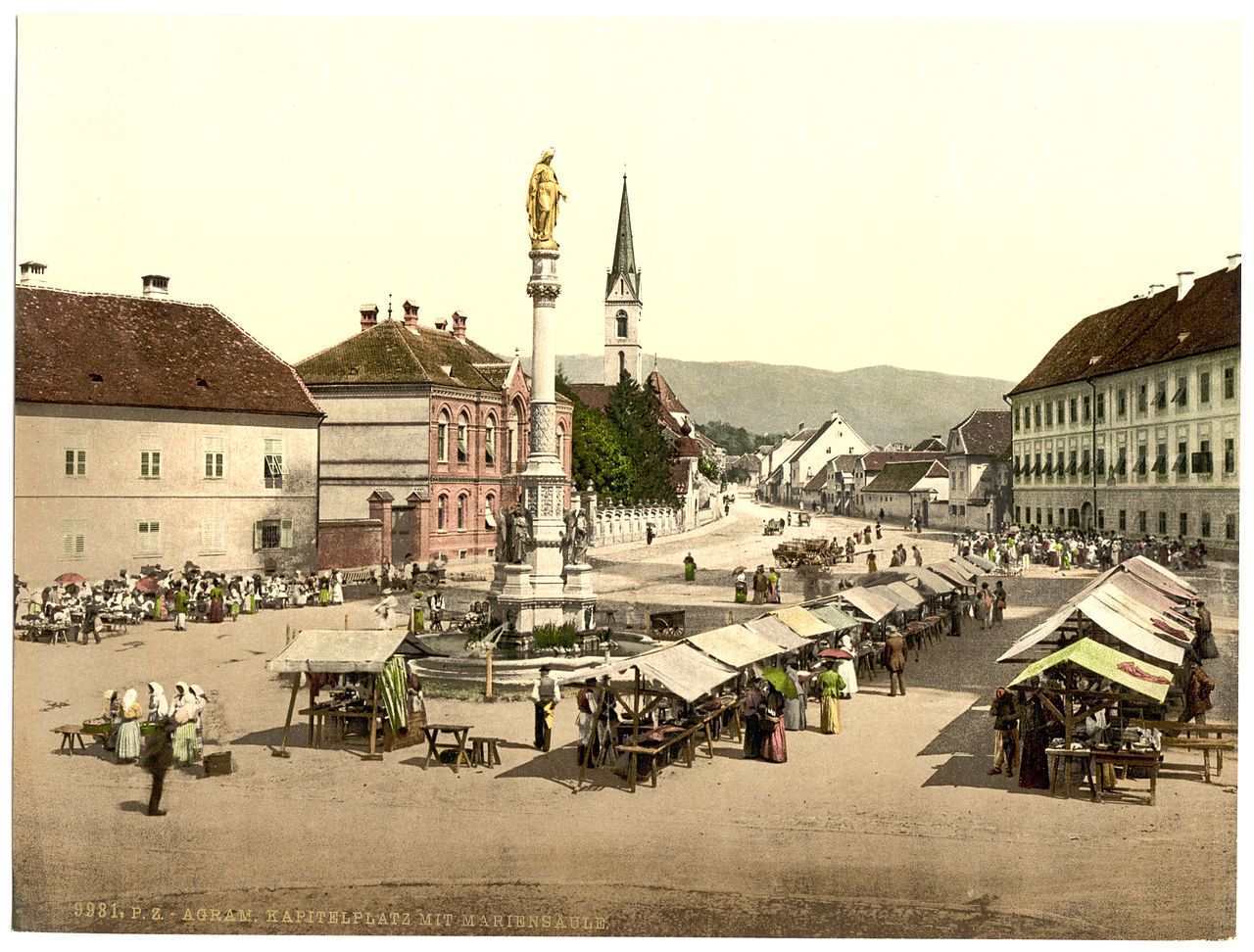 Kaptol, Zagreb in 1905, when almost every day looked like European Car Free Day
Tomorrow, Zagreb will return to a pace more familiar to former inhabitants as the city observes European Car Free Day. Motor vehicles will be banned from much of the city's centre between 8 am and 8 pm.
The area of the city centre observing European Car Free Day has the following boundaries; Trg bana Josipa Jelačića - Jurišićeva - Palmotićeva (western edge) - Boškovićeva (northern edge) - Hebrangova (northern edge) - Gundulićeva (eastern edge) - Ilica (northern edge) - Mesnička (eastern edge to Streljačka) - Mesnička - Demetrova - Ilirski trg - Radićeva - Trg bana Josipa Jelačića.
These streets form some of the oldest parts of Zagreb. Long have they been trodden by the pedestrians to whom they'll return tomorrow. Those travelling into the centre by car must park on the outskirts and take public transport into the heart of the city. Trams, taxis and buses will operate as normal.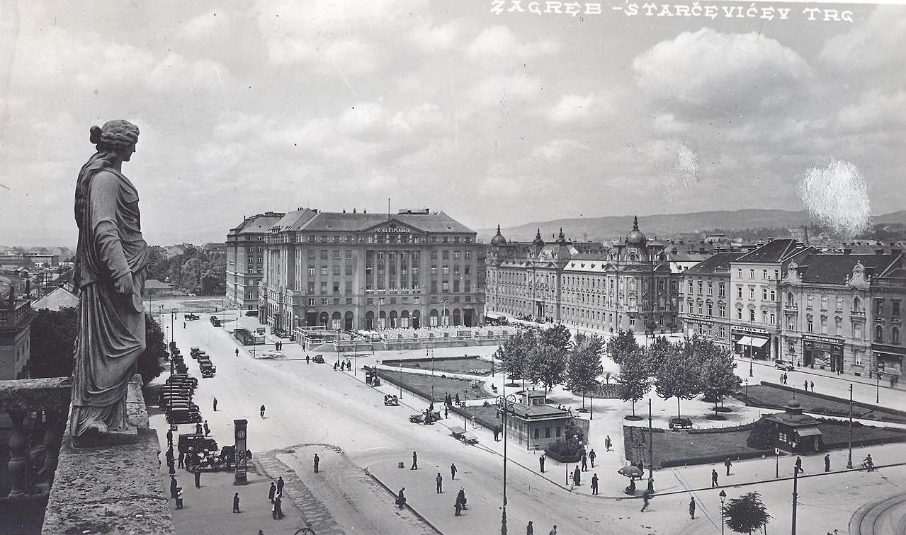 Cars began to be seen more regularly in Zagreb during the first half of the 20th-century. Not so much a European Car Free Day as a Croatian Tram Free Day - the city's famous tram network wasn't nearly so developed back then. The first city in Croatia to have trams was actually Osijek, who introduced a horse-pulled tram network in 1884.
The observance of car-free days is actually over 65 years old, although originally they were introduced in response to oil crises, not for environmental reasons. The more modern reason for having such days is to return city streets to pedestrians. Car-free days have taken place independently in European nations since the mid-1990s, and it 2000 they became aligned on the fixed date of 22 September. European Car Free Day is also a car-free day in many other countries outside of Europe, although this continent is the only one to currently observe it throughout its boundaries.
All uncredited photos lie within the public domain.
For the latest travel info, bookmark our main travel info article, which is updated daily.
Read the Croatian Travel Update in your language - now available in 24 languages
Maslenica Bridge on A1 Motorway Closed 10 Cumulative Months Since 2008
According to data collected by Croatian Highways (HAC), the Maslenica Bridge on the A1 Motorway has been closed to traffic for 10 cumulative months since 2008. Residents of Dalmatia had believed for decades that their isolation would cease after the highway connecting them to continental Croatia was completed. They also welcomed the arrival of the Karlovac - Zadar - Split section of the A1 motorway route, including the "New" Maslenica Bridge, which officially opened on June 26, 2005.
But that good fortune only lasted until the first big storm, according to Jurica Gašpar/Morski on December 29, 2019. From then on, depending on wind speeds, the section spanning the Sveti Rok Tunnel to the Maslenica Bridge would regularly close to vehicles of all sizes in order to protect passengers.
Maslenica Bridge Closed to Traffic More Frequently
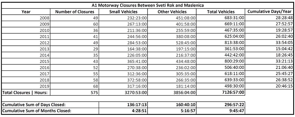
Nothing has changed since then except for the frequency of the motorway closures. For the last seven years this section has been closing even more frequently. So, 2019 will be remembered as the year it closed 68 times, which is the most it has ever been closed for traffic. By the end of this year, this section of the A1 had not seen traffic for more than 498 cumulative hours, or almost 21 days.
Courtesy of Croatian Highways (HAC), there is detailed bridge closure information from January 2008, the creation of the their database, to December 2019. During this time period, a total 575 traffic closures of the Sveti Rok - Maslenica section have been recorded, with a duration of almost 7126 cumulative hours or 297 days, which amounts to almost 10 months of traffic closures on this most delicate part of the A1 motorway.
Bora Closed Maslenica for 34 Cumulative Days in 2012
Regarding closures due to the Bora (extremely strong wind in Adriatic Coast), 2013 was the most peaceful year because the motorway closed only 29 times for almost 362 hours, or 15 cumulative days. And although the previous record for number of traffic closures the (60 in 2009) was not surpassed in 2012; the record was eclipsed for cumulative hours closed. Traffic was banned on this section spanning Sveti Rok Tunnel and Maslenica Bridge for 813 cumulative hours, or more than one month (almost 34 days).
See the table below for more details:
The Maslenica Bridge (called the "New Maslenica Bridge" to distinguish it from the "old" one, which was bombed during the Homeland War and rebuilt in 2004) has been subject to a great deal of public and media scrutiny because of frequent closures due to the storms.
Hurricane Force Winds Hit Bridge at Aggravating Angle
The highest Bora wind speed at Maslenica Bridge was recorded on December 21, 1998. At that time, wind gusts reached hurricane force levels of 248 km/h. Experts say the problem is that the wind does blow crossways, but at a 10-15 degree angle toward the bridge, which is an aggravating factor.
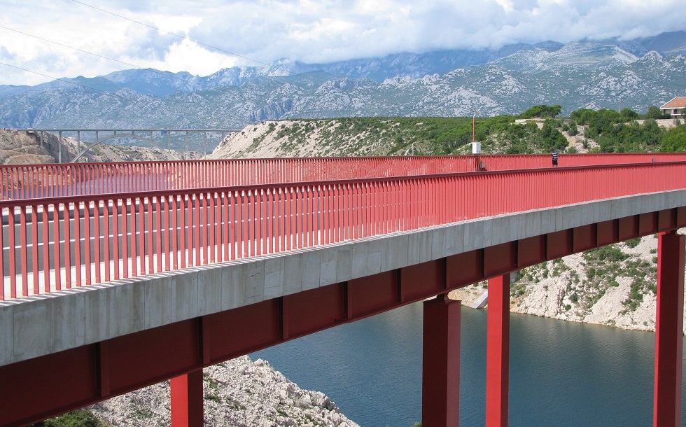
View of 'New' Maslenica Bridge from 'Old' Maslenica Bridge | Wikimedia Commons
Local Shepherds’ Advice Ignored for ‘New’ Bridge
Senior residents in the area recall that the builders of the "Old" Maslenica steel bridge on the D8 state road had inquired with locals about the best location. Shepherds reportedly responded by pointing out places where animals gathered and evacuated during the strongest winds. The first bridge was built on that site, and that turned out to be a successful choice because the Bora has hardly ever closed this bridge. The same cannot be said for the “new” bridge, of course.
Therefore, it’s no surprise that builders hadn’t taken any wind speed measurements for the area of the planned A1 motorway section spanning Sveti Rok – Maslenica before they began construction on the new bridge. Later measurements showed that this area between Marun and Crnava draga is the windiest – and that’s exactly where the highway was built. The average wind speed there is 32 kilometers per hour.
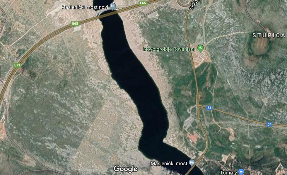
'Old' and 'New' Maslenica Bridges on Map
Most Expensive Motorway Section in Dalmatia
There is enough material to write a book about the politics, historical circumstances and (not) listening to locals and professionals regarding the planning and construction of this section, so those details will be left out of this text. Just the construction of the Sveti Rok Tunnel alone amounted to 1.5 billon HRK (20.1 million EUR), and billions were involved in building the connecting motorway over viaducts, overpasses and ultimately the Maslenica Bridge, which makes this section by far the most expensive motorway in Dalmatia. Therefore, each closure costs millions.
Suffice to say that Maslenica bridge closure has become more frequent issue and an adequate solution has not been found or implemented. But that's why Dalmatia has the most expensive toll road in Europe.
Follow our Travel page for more information, updates and upgrades on infrastructure in Croatia.


