Snow on Islands, Chaos on Roads in Croatia
January 22, 2023 - After a very mild couple of weeks, snow has blanketed much of Croatia, causing chaos on the roads, reports Index.hr
A sudden cold snap in Croatia has covered much of the country in snow, including Dalmatian islands such as Vis, Brac, Hvar and Korcula (see Korcula in the video below), causing multiple problems on Croatia's roads.
The latest update from HAK (Croatian Roads) offers this advice (you can find the updated news on this link):
Throughouth the interior and in Dalmatia traffic is flowing with delays due to snow. Roads are very slippery too. Along the coast strong wind is blowing.
Due to very strong wind passenger traffic is allowed only:
- on the DC25 Gospić-Karlobag state road;
- on the section of the DC8 Adriatic road Karlobag-Sveta Marija Magdalena.
On the A7 Draga-Šmrika motorway there is a traffic ban on: doubledeckers, trailers, motorcycles, on the part of the DC8 Adriatic road Bakar-Karlobag, on the DC99 Križišće junction-Križišće state road and on the LC58107 Kraljevica-Križišće local road on the delivery vans and vehicles with covered cargo area too.
At Krk bridge traffic is suspended for: motorcycles, campers, campers with three or more axles, vans over 1,9 m of height, doubledeckers and passenger vehicles with a one-axle-trailer.
Due to winter driving conditions there is a traffic ban on freight vehicles with trailers and all other vehicles have to use the winter equipment on the following roads of
Gorski kotar mountain area:
- Karlovac-Zdihovo-Delnice-Kikovica;
- most state, regional and local roads in the area of Čabar, Vrbovsko, Delnice, Gornje Jelenje;
Lika mountain area and in the central parts:
- DC1 Vaganac-Korenica-Gračac-Knin;
- DC6 Jurovski Brod-Karlovac-Vojnić;
- DC23 Duga Resa-Generalski Stol-Josipdol-Kapela;
- DC25 Korenica-Lički Osik;
- DC27 Gračac-Zaton Obrovački;
- DC42 Josipdol-Plaški-Saborsko-Kuselj;
- DC50 Žuta Lokva (DC23)-Lički Osik, Sv. Rok-Gračac;
- DC52 Špilnik-Korenica;
- DC204 Pribanjci border crossing-Bosiljevo junction;
- DC217 Ličko Petrovo Selo-Ličko Petrovo Selo border crossing;
- DC218 Bjelopolje-Donji Lapac-Užljebić border crossing;
- DC220 Tijarica (Vukina Strana)-Kamensko;
- DC228 Jurovski Brod (DC6)-Kamanje-Ozalj-Karlovac (DC1);
- DC429 Selište Drežničko-Prijeboj;
- DC522 Udbina-Gornja Ploča;
- DC541 DC6-Novigrad junction (A1)
- ŽC5144 Sveti Juraj-Krasno;
- ŽC5140-Krasno-Otočac;
- regional and local roads in the county of Ličko-senjska.
Traffic is suspended:
- on the DC36 Karlovac-Sisak state road on the section Pokupsko-Hotnja, at Gradec Pokupski and Jamnica (due to flood);
- on the DC547 Sveti Rok-Mali Alan state road (due to winter driving conditions);
- on the ŽC5217 Bruvno-Mazin-Dobroselo and ŽC5203 Srb-Otrić regional roads (due to winter driving conditions).
On the DC5 Okučani-Lipik state road traffic is flowing with delays (driving speed limit of 30 km/h).
On the DC47 Trokut-Novska junction (A3)-Hrvatska Dubica-Hrvatska Kostajnica (DC30)-Dvor (DC6) traffic is suspended for vehicles over 7,5 tonnes (driving speed limit of 40 km/h).
Drivers are asked to adjust the way of driving and driving speed to road conditions, to keep the safety distance and not to start the journey without the winter equipment!
Difficulties can occasionally occur in roadwork areas.
Novi Vinodolski Flooding Raises Cause for Concern
November the 18th, 2022 - Novi Vinodolski flooding is causing cause for concern among many, and although the Republic of Croatia, at least in some parts, is no stranger to floods, the sheer level of rainfall which has caused this was unexpected.
As Poslovni Dnevnik writes, it has been raining fairly heavily and continuously since the early morning hours in parts of the country, and in some locations this has been accompanied by thunder and other stormy weather. A huge amount of precipitation fell on Novi Vinodolski, where some roads were closed, and now Novi Vinodolski flooding is another issue for residents.
In some places, the water is knee-deep.
For more, keep up with our news section.
Weather Lore in Croatia: Lokve Folk Calendar Predicts the Weather in 2022
January 9th, 2022 - How did people go about predicting the weather back in the day, before the invention of measuring instruments? Looking into a traditional method preserved in Lokve, a town in Gorski kotar where folk meteorologists predict the weather for the year ahead based on a short period in December
We’re a bit spoiled these days with detailed weather forecasts awaiting only a few clicks away. Have you ever wondered how people used to go about this before weather apps and modern meteorology? With no measuring instruments yet invented, they had only their environment and the skies above to rely on, giving way to a diverse body of weather folklore.
There are many folk sayings and customs related to weather in Croatia - too many for a single post. This time, we’ll focus on an old tradition that’s been passed down for generations among the people of Lokve, a town in the Gorski kotar region.
Called ‘brojanica’ in Croatian, the traditional method allows for predicting what the weather will be like in the entire year based on a short period in December - a fine example of weather lore preserved to this day.
Local folk meteorologists in Lokve carefully track weather conditions and changes during the 12 days between the holiday of St Lucia (December 13th) and Christmas Eve (24th). Each of those days is associated with one of 12 months in a year; the weather conditions recorded on a given day are taken as a forecast for the whole related month, with some adjustments to fit the different seasons. E.g. if it’s cold and sunny on St Lucia, it’s expected that the whole month of January will be cold and sunny as well.
Lake Lokve / velfran
Novi list reported that the diligent folk meteorologists in Lokve kept a close eye on the weather this past December as well, resulting in publication of the 2022 Lokve calendar with the forecast for the entire year.
What awaits us in 2022? The calendar designer Nikola Pleše says we don’t have to worry about extreme weather this year.
‘Tracking of the weather conditions between St Lucia and Christmas Eve has shown that those 12 days didn’t bring any extremes, so based on our tradition and folk wisdom, we don’t expect anything too dramatic in regards to weather conditions this year’, he said.
The forecast for January has already proven to be true. ‘In the first week of the new year, St Lucia will unfurl a tall, grey fog over Lokve and only show us sunlight and moonlight in traces. From the 20th of the month, days will be clearer and calm, but colder’, says the calendar. And even though this refers to Lokve in particular, the nearby Kvarner bay has also been completely enveloped in thick fog for the first week of 2022.
In the poetic forecast for the month of February, it’s said that ‘the skies will hide behind a tall, thick fog, in which not even little birds will dare to make a peep. From February 15th onwards, the sun will rip the fog apart…’.
Not much for the people of Gorski kotar to look forward to in March either: ‘Days will remain drooly, full of fog, adorned by a rare snowflake or glistening frost’, up to March 20th when the northern winds are expected to sweep the fog away.

Come April, the weather will finally start looking up, and in May, ‘days will be bright and warm, making people, birds and plants more cheerful.’ This trend will keep up in June, as the month is to be ‘sunny and dry, already in full bloom by Midsummer’s day (Ivanje), and more humid and hot towards St Peter’s Day (Petrovo).’
A lot of wonderful summer weather in July and August as well, leading to a bountiful harvest in September. ‘It will be a sunny, clear month, smelling of the abundance of everything we’ll have planted in Lokve soil this spring’, says the forecast.
And that’s about it when it comes to nice weather in Lokve this year. The last three months of 2022 will supposedly be quite damp, same as in the beginning of the year. A lot of fog, frost, and cold wind are expected in autumn, but it won’t be too cold until late December when the southern jugo wind will be replaced by the dry bura wind that will have the temperature drop sub zero and usher in the winter season.
The weather forecast for this year’s weather calendar was created by Mirjana Pleše and her daughter Ivana, Andreja Marković, Tanjica Šafar, Marijana Rakas and Eleonora Grgurić, with Nikola Pleše behind the calendar’s graphic design.
Beyond the folk traditions, Lokve is a fantastic destination for a day trip that will delight any fans of outdoor activities. The town is home to the cave Lokvarka, the deepest cave in Croatia open to the public. Not a fan of subterranean strolls? Head to the nearby Lake Lokve (Croatian: Lokvarsko jezero) for a scenic walk or a bike ride with a view. Make sure to contact the local tourist board beforehand, though - the (artificial) lake will be drained for a period of time in 2022 for regular maintenance, so you might as well know what kind of view to expect during your visit!
Showers, Winds, and Thunderstorms: Weather in Croatia Starts to Change This Week
August 23, 2021 - This year's very hot summer will be interrupted this week by a few days of rain and thunderstorms, perhaps marking the beginning of a slow transition to lower temperatures as the weather in Croatia begins to change.
Despite still feeling the high temperatures throughout the country, it could be said that intolerable heat waves are a thing of the past. During June, July, and the first weeks of August, both locals and tourists had to endure frequent temperatures between 34 and 38 °C. Now, recent forecasts indicate that the weather in Croatia will be milder, with temperatures hardly exceeding 30 °C.
Also, the nights begin to be cooler, the mornings colder, and the sky begins to darken a little earlier than before.
Although the high temperatures attracted both Croatians and foreigners to take a dip in the Adriatic, as well as in the lakes and rivers, it is worth mentioning that they brought with them difficulties such as fires along the Croatian coast.
As reported by 24sata.hr, gradual cloud cover from the northwest with occasional rain and showers, which may be more pronounced locally. In the east of the country and especially in Dalmatia most of the day is partly sunny and mostly dry.
On the mainland, a moderate, in some places moderate and strong north and northeast wind will blow from time to time. The moderate south wind in the northern and part of the central Adriatic will turn into a moderate and strong bora, under Velebit and with storm surges.
The highest daily temperature from 23 °C in the western parts of the interior to 29 °C in the east, and in the Adriatic and in the interior of Dalmatia from 27 to 32 °C, is the forecast of the State Hydrometeorological Institute (DHMZ) for Monday.
Today, a yellow meteorological alarm was issued for almost the whole of Croatia, except for the extreme south, while an orange alarm was issued due to the strong wind in the Velebit Channel.
Tomorrow will be changeable with sunny periods. Occasional rain, showers, and thunderstorms, especially in Dalmatia, in the morning in Slavonia.
Wind mostly weak north, moderate in the Adriatic, in the northern part, and strong bura with storm gusts mainly at the foot of Velebit, and in the south and northwest. Lowest temperatures from 12 to 17, at sea between 19 and 24 °C. The highest daily is from 19 to 24 °C, on the Adriatic between 26 and 31 °C.
If you want to learn more about the weather in Croatia, be sure to check out Total Croatia's guide here.
Temperatures in Croatia to Reach Summer Levels this Week
14 June 2021 – After unstable weather throughout spring, Croatians and their guests are finally going to see summer weather, perfect for the beach. A look at temperatures in Croatia this week.
Croatians, especially along the coast, have been complaining about relatively cool May. By June, the coastal region of Dalmatia is usually seeing busy beaches and plenty of people enjoying the warm Adriatic Sea. This year, however, temperatures are rising slowly and the weather has been quite unstable. This is about to change according to index.hr. During the week we are to see rising temperatures across Croatia exceeding 30°c for the first time this year.
Monday will most probably remain unstable with windy and cool weather in the areas of high elevation and northern Bura wind potentially very strong around the Velebit Mountain region. The remainder of the week will be more stable with rising temperatures. We are to see true summer temperatures in Croatia. Already on Monday, we are expecting daily values in Central Croatia to reach 23°c-25°c, while those in Dalmatia will be reaching daily highs of 26°c-28°c. As it stands now, many Croatians and foreign visitors to the country will enjoy true beach weather this week. Many will be relieved after struggling with chilly waters and fickle weather throughout may and the beginning of June.
Potential for Heat Wave
All is not well for those without a high tolerance for heat. Croatia might be getting the first heatwave of the year. These instances of hot weather that border on unhealthy levels are nothing unusual in Croatia. Every summer there are days when government warnings about health hazards tied to high-temperature exposure need to be broadcasted. The danger of heatstroke and sunburn are all too real during the hottest days on the Croatian coast. If you are visiting Croatia in the second half of the week, make sure to pack plenty of sunscreen and water. Locals will just be happy to finally be able to switch completely to summer clothes.
For more information to help you make the best of your Croatian holiday, check out our travel section.
Croatia Temperatures Will Reach 20 Degrees This Week: End of Winter?
March 9, 2020 - Temperatures will reach 20 degrees in parts of Croatia this week and above average temperatures are expected Wednesday through Friday. Local meteorologists share their thoughts on whether Winter is officially over.
The Croatia State Meteorological Institute posted a forecast for the coming week and, as things stand, temperatures will rise quite a bit, according to Željka Orešković/Telegram on March 9, 2020. It looks like weather will be spring-like, with alternating sun and clouds, and there may be a few brief showers. However, that doesn’t mean that the definitive end of winter has arrived.
Telegram consulted with the experts, N1 television meteorologist, Tea Blažević, and Nova TV meteorologist, Darius Brzoja, and asked them to provide more detail about what to expect this week. They agreed that we cannot expect a long-term weather stabilization and that the end of Winter cannot yet be confirmed.
Croatia Temperatures Will Reach 20 Degrees Celsius
"The temperature will rise, especially on Wednesday and Thursday. On Wednesday, the Banovina and Kordun areas will be the warmest, where temperatures will reach 20 degrees. On Thursday, however, we can expect temperatures around 20 degrees for most of the interior, and up to 21 in some places, which is definitely above average,” Blažević predicts, adding that she would not speculate on the end of winter because this is quite short-term. Meteorologist Brzoja agreed with her assessment.
"This week will be warmer, especially on Wednesday, Thursday and Friday. In many parts of the country temperatures will reach 20 degrees. It will be warm even in the highlands, where it will be at least 15 degrees, if not more. It will be the same in coastal areas. However, sea temperatures are still cool during the beginning of spring, which does not allow air temperatures to rise as they would on land. Maybe temperatures will hover around 20 degrees along the Southern Adriatic,” he added.
Although it will be mostly dry and sunny until Friday, it will get worse by the end of the week. "Toward the end of the week temperatures will fall again, and they could be even slightly lower than average. This will be compounded by worsening conditions expected on Friday. By Friday it will be mostly dry with light showers at night from Monday to Tuesday,” Blažević says. Brzoja adds that Tuesday will be cool but will be warmer than today.

Dario Pribeg | Unsplash
Dry with Intermittent Clouds This Weekend
Although the forecasts for the weekend are a bit more uncertain, except for the rain from Friday to Saturday, it should be relatively dry with intermittent clouds. "It's not going to be a completely sunny weekend. It may rain early Saturday, but mostly dry throughout the day. Problems may arise from by a storm near Velebit. It is expected to start at the end of Friday, and continue into the night on Saturday, which could cause traffic problems,” Blažević says.
Dario Brzoja, on the other hand, foresees colder mornings: “Wednesday to Friday will be a beautiful introduction to spring. It's first sign of Spring, so people will enjoy it and feel the spring coming. However, he emphasized that the mornings will be quite chilly. It will be between 0 and 5 degrees inland, which means that everyone should dress appropriately (in layers) to stay warm enough in the morning and not get too hot in the afternoon."
Follow our Lifestyle page for updates on the arrival of Spring 2020 in Croatia.
Croatia Winter Finished According to Latest Weather Forecasts
According to the most recent forecasts, Winter in Croatia is finished. In the current part of the climatological winter, which began on December 1, we have not yet had a single winter cyclone, and no significant snowfall, even in most of the higher elevations.
According to a report by DHMZ, measurable snow cover has been only recorded at 5 locations in Croatia as of this morning, the most of which was 5 centimeters in Zavižan, which will quickly melt, Istramet reports.
The lowlands of the interior of Croatia have recorded only a brief snowfall this winter, and central Istria has not even had any snow.
Croatia Temperatures Noticeably Above Average
In terms of temperature, we are well above average, especially in the highlands and the Adriatic. The plains of the interior of Croatia have been spared from temperature extremes by a prolonged inversion, but due to the more intense sun and wind, they will be even less frequent in the coming weeks.
Weekly Forecasts Indicate That Winter is Over
According to the ECMWF monthly forecast published on the EFFIS website today, winter in Europe is over.
Specifically, a positive temperature deviation is expected every week until March 1, which is the beginning of the climatological spring. The anticipated temperature deviations have been noticeable and the most evident in Russia, where the real winter breakthroughs are anticipated.
This is not to say that there won’t be any short-lived fronts or maybe cyclones which bring snow, but regarding big winter events, it seems that nothing significant will occur. This is further supported by the fact that less than average rainfall is predicted, which suggests the continued dominance of warm anticyclones, Istramet reports.

Darko Pribeg | Unsplash
What do long term forecasts say?
The Severe Weather Europe Service also announced yesterday what it expects to happen in February. They also predicted what spring might be like.
Given that high air pressure will remain over much of Europe and Asia, temperatures are expected to be above average for the season during February. This means that there is a greater likelihood that there won’t be any real winter weather over continental Europe. As Severe Weather Europe Service notes, there is always the possibility of a transitional cold pattern as a cold front could cross over Europe, but according to current forecast models there is very little likelihood of this. As we move into February, the polar vortex slowly loses its effect and any major change in dynamics, in terms of the arrival of cold fronts, would be too late to create a sustainable pattern of cold weather.
What kind of Spring is ahead of us?
According to ECMWF's Severe Weather Europe model; it has provided insight regarding what this year's spring in Europe might look like.
The ECMWF model suggests a spring pattern, which is like winter. High air pressure systems are evident in the North Pacific, Western Atlantic and Europe.
Taking the high air pressure into account for March, April and May; air temperatures are expected to be higher than average for this time of year in Europe and Asia.
As for precipitation, drier weather is expected in southern Europe, which correlates with higher air pressure. Continental Europe should experience average rainfall, which means that no long droughts are expected. Lower pressure over the Atlantic could lead to higher rainfall in Central and Northern Europe.

Danijela Froki | Unsplash
Zoran Vakula’s Long Term Weather Forecast
In an interview with Zoran Vakula of Slobodna Bosna, he revealed what to expect in the upcoming months.
"The data from DHMZ meteorological stations confirms that this winter so far is among the warmest, in many places on the Adriatic and in the highlands and among the 10 warmest in since the beginning of recorded weather measurements.”
“Even in long-term forecast calculations of most meteorological centers - there are no expected changes for the remainder of winter. For our part of Europe, it is still very likely that anticyclones - high-pressure fields with relatively frequent temperature inversions will be accompanied by the retention of relatively warm air in higher layers of the atmosphere, which will continue to be noticeable.”
“Therefore, it seems almost certain that the mean air temperature in the highlands and Adriatic will continue to be higher than the average, in many places considerably higher, while long-term fog and low retention clouds could ‘save’ lowlands from those above average highs. If this is the case, we will still have very little rainfall in the winter, but pollution in the lowlands could still be high. But I hope that we will still have some wind, which will make that impossible in the lowlands."
“Regarding summer, I do not have any long-term prognostic calculations, but according to what is available up to July – it is unlikely that there will be any long-term cool periods over the upcoming months in our part of Europe. Unless one arrives at the end of one month and lasts until the beginning of the following month, this isn’t evident in the calculations of the mean monthly air temperature, since periods with above average temperatures will likely prevail.”
“In contrast to this positive temperature deviation, precipitation forecasts are showing an increased likelihood of negative deviations, which are somewhat less than the perennial average. In short, it will be relatively warm and arid in the first part of 2020! But of course, this is what is most likely now, and is not certain. The prognosis is not the diagnosis.”
“With forecasts, it's important not to overlook the probabilities. Sometimes there is an occurrence for which the forecast probability had been low, or even minimal, such as May 2019, which was one of the coldest in known history, although at the end of that April it was only considered a low probability. As it turned out, last May was among the ten, or even four, coldest in most of Croatia,” Vakula points out.
Follow our Lifestyle page for updates on weather forecasts for 2020.
VIDEOS: Great Footage of Large Waterspouts Near Split
November the 29th, 2019 - Sometimes, waterspouts develop on the Croatian Adriatic sea and while these incredible sights are not all that uncommon at this time of year when the weather tends to be unstable, have you ever had the chance to get a clear view of one, and film some waterspouts near Split?
The weather in Dalmatia at this time of year can be pretty all over the place. From warm sunny days that require the removal of jackets and the placement of sunglasses in the middle of November to extreme winds like jugo and bura blowing tables and chairs down the streets. All this can happen in just one day. While this is irritating for residents and tourists alike, it makes for some amazing photos and videos.
As Morski writes on the 28th of November, 2019, Thursday this week was marked by very poor weather conditions along the Dalmatian coast, and these unstable conditions created numerous waterspouts (pijavice). Just after the last set of tumultous weather, it seems that this is the beginning of yet another volatile period. According to Pljusak.com, more abnormally heavy rainfall has hit parts of Dalmatia.
At aound 15:00 on Thurday, a powerful thunderstorm cloud developed above the Brač channel, where an impressive waterspout near Split formed, the largest in the area since August 2018 when Podstrana took a beating by the elements, Dalmacija Danas reports.
The waterspout near Split, despite being very well developed and large in size, thankfully does not seem to have reached the actual shoreline of the City Split. In addition to that, very heavy rainfall began in parts of the city and there was even a brief period of hail in some places.
Watch the amazing videos from Dalmacija Danas' YouTube channel of the waterspouts near Split below:
Make sure to follow our dedicated lifestyle page for much more.
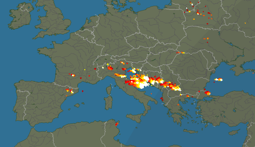
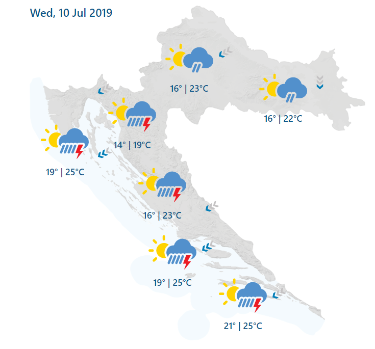
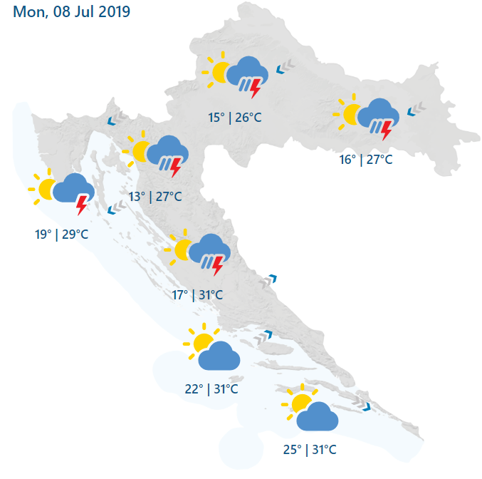
26,000 Bolts of Lightning in 2 Hours: Storms Return to Peak Season Adriatic Coast
July 9, 2019 - Storms return to the Croatian coast - spectacular shows but not for those in search of a sunshine holiday.
If you like storms, the Croatian coast is the place to be right now, with more bad weather descending on peak season destinations.
According to Dalmacija Danas, some 26,000 bolts of lightning were recorded in just 2 hours.
And looking at the Blitsortnung website, which monitors such things in real time, Croatia is right at the heart of things.
Live updates with photos and videos from Dalmacija Danas here.
For tourists wanting to know the latest road conditions, visit the official English-language Croatia Automobile Club website (HAK) for the latest advice.
For the latest weather info, click here.
And if you are bored and want something to read, here is the latest TCN editorial from earlier today: Does Croatian Tourism Have a Plan B is Climate Change is Real?
Storms in Croatia: Hail Damages Houses, Cars in Osijek and Vukovar
July 8, 2019 - After a period of intense heat, storms have returned to Croatia, with hail doing particular damage in the north-east of the country.
As reported last night on TCN, parts of Croatia were given a severe and sudden change in the weather after the recent hot spell. In Rijeka, just after midday, for example, the temperature dropped 8 degrees Celcius in 20 minutes, during which time there was a torrential downpour.
Things were a lot worse in other parts of the country, as Index reports, particularly in the east, where large hail stones damaged roofs in Vukovar and several windscreens of cars in Osijek. while two elderly women were slightly injured by the hail in Borovo Naselje.
The bad weather made its way down south as well, with winds, thunder and lightning in Dalmatia. Below a selection of videos from around the country.
With the unpredictability of the weather affecting driving conditions, tourists are advised to check the Croatian Auto Club official advice (in English) for the latest information here.
For the latest weather forecasts in English, click here.