With the First Day of School Around the Corner, the Split-Dalmatia Police Department Takes a Stand for Safety
With the start of the new school year quickly approaching, the Split-Dalmatia County Police Department has implemented the action 'Respect Our Signs' in an effort to increase the level of safety for children and all other road users.
The Museum of Cetina Region and Sinj Celebrates 60 Years Tonight
For the 60th anniversary of the Museum of Cetina Region - Sinj, the exhibition 'Pokrenimo muzejske zbirke' which presents selected collections from the museum's exhibitions as part of the permanent exhibition, will be displayed. The exhibition will open this evening at 20h.
Summer Events in Vrgorac
We've put together a list of all the events going on in Vrgorac this summer, and we promise, there are plenty to choose from!
EU Funds - Are they Helping to Decentralize or Further Centralize Croatia?
Do all regions in Croatia have a fair shot at EU funds? A very interesting analysis by Šime Erlić, head of the EU funds department in the Zadar City Council.
Celebrate Earth Day With These Stunning Images of Croatia
North, South, East and West...Beauty of Croatia through the lens of Romulić & Stojčić
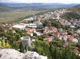
KLIS
 The Klis fortress, one of the most significant fortifications in Croatia, due to its strategic importance had a significant defense position. From the 2nd century BC this area was inhabited by the Illyrian tribe of Delmati, while the first records about the fortress from the 10th c. speak of the Roman fortress Kleisa being besieged by the Avars and Slavs which hastened the conquering of Salona in the first half of the 7th century at the time of arrival of the Croats. Two centuries later Klis had already become the ruler’s property and one of the centers of the Croatian state.
In the document issued by prince Trpimir in 852 the court is mentioned as his property, and it also became the center of the Early Croatian Primorska (Littoral) or Klis County (Parathalassia).
The end of the 11th century was marked by the end of the Croatian national dynasty and Klis fell under the rule of the Hungaro-Croatian kings. One of them, Bela IV and his family used the Klis fortress as shelter during the Tatar siege in 1242.
By the end of the 12th century Klis was ruled by the princes Šubics’ of Bribir, the mightiest family of Croatia, and from 1335 the town was again under the protection of the king and the administration of its fortress commanders.
The most turbulent time of the history of Klis was the beginning of the 16th century, the time of the greatest Turkish invasion to these areas. An important role in its defense was played by Petar Kružić, captain and town duke, who together with his warriors (Uskoks) managed for two and a half decades to resist Turkish attacks and besieges. With his death on March 12, 1537, Klis fell under Turkish rule which meant the loss of the most powerful Croatian fortification in Dalmatia. For 111 years the Jadro River was the border between the Turkish Klis (Kliški Sandžak) and the Venetian controlled Split. During one of the attempts to liberate Klis, the Croats led by Split noblemen Ivan Alberti and Nikola Cindro utilized the element of suprise and managed to take over the fortress in April 1596. However the Turks conquered it again by the end of May, thus defeating Croatian general Juraj Lenković who came to the aid of the defenders.
As late as March 31, 1648 the Venetian army led by general Leonardo Foscolo, joined by the numerous Croatian locals, managed to liberate Klis from the Turks after 10 days of hard-fought battles and achieved its greatest success during the Cretan War.The area of Klis was organized as a special military
and administrative area ruled by the providur based in Klis.
The Klis fortress, completely restored and significantly enlarged, remained under the flag of Venice until 1797 when it was taken over by the Austrians. From 1805 until 1813 it was shortly ruled by the French. The period of the second Austrian administration lasted until the end of World War I in 1918, when, with the fall of the Austro-Hungarian Monarchy, Klis, together with the remaining parts of Croatia shared the same fate of all Croatian lands within the borders of the Kingdom of Serbs, Croats and Slovenes, and afterwards Yugoslavia.
During World War II, from April 1941 until October 1944, the Klis fortress was for the last time used for military purposes, mainly as the stronghold of Italian and German occupation forces. Finally in 1990 the flag of the sovereign Repubic of Croatia was placed on it.
Area: 176 km2
Population 2001
- City: 4.421
City Municipality:
Brštanovo, Dugobabe, Klis, Konjsko, Korušce, Nisko, Prugovo, Veliki Broćanac i Vučevica.
City of VRGORAC
 Vrgorac is medieval Inland Dalmatia's town. Located on the northeastern slopes of the Biokovo mountain in the vicinity of Dubrovnik- Neretva County and Bosnia and Herzegovina. Within a radius of thirty kilometers associated with the attractive tourist destinations such as Makarska and the Makarska Riviera , Medjugorje and Metković.
The town of Vrgorac, although a small place, is where great people and great things are born. Tin Ujevic, Croatia’s most significant poet and writer was from Vrgorac. His prominent literary creations have named him the greatest Croatian writer of the 20th century. Stipe Bozic was also born in Vrgorac, in 1951. He is well known for his filmmaking and also for being the second European to have climbed Mount Everest twice! This stunning region is truly one of Croatia’s secret treasures.
Historical monuments from the past can still be seen all throughout the city and its surroundings. The seven forts dating back to the 14th century, once served as a defence system against the Turks who ruled this region for over 200 years border the entire town of Vrgorac. The Fort of Gradina is the main fort, which overlooks all of Vrgorac and the plains below. It provides a stunning lookout point with a beautiful hiking path from the city centre.
Everyone’s favorite fruit, the sweet strawberry, is Vrgorac’s crowning glory with hectares and hectares of stunning strawberry fields dotting the valleys of this incredible destination.
 Area: 284 km2
Population 2011
- City: 2.188
- Urban: 7.593
Elevation: 241 m
Tourist Board:
- +385/21/ 675 110
- This email address is being protected from spambots. You need JavaScript enabled to view it.
City suburbs:
Banja, Dragljane, Draževitići, Duge Njive, Dusina, Kljenak, Kokorići, Kotezi, Kozica, Mijaca, Orah, Podprolog, Poljica Kozička, Prapatnice, Rašćane, Ravča, Stilja, Umčani, Veliki Prolog, Vina, Višnjica, Vlaka, Zavojane, Kutac
City of TRILJ
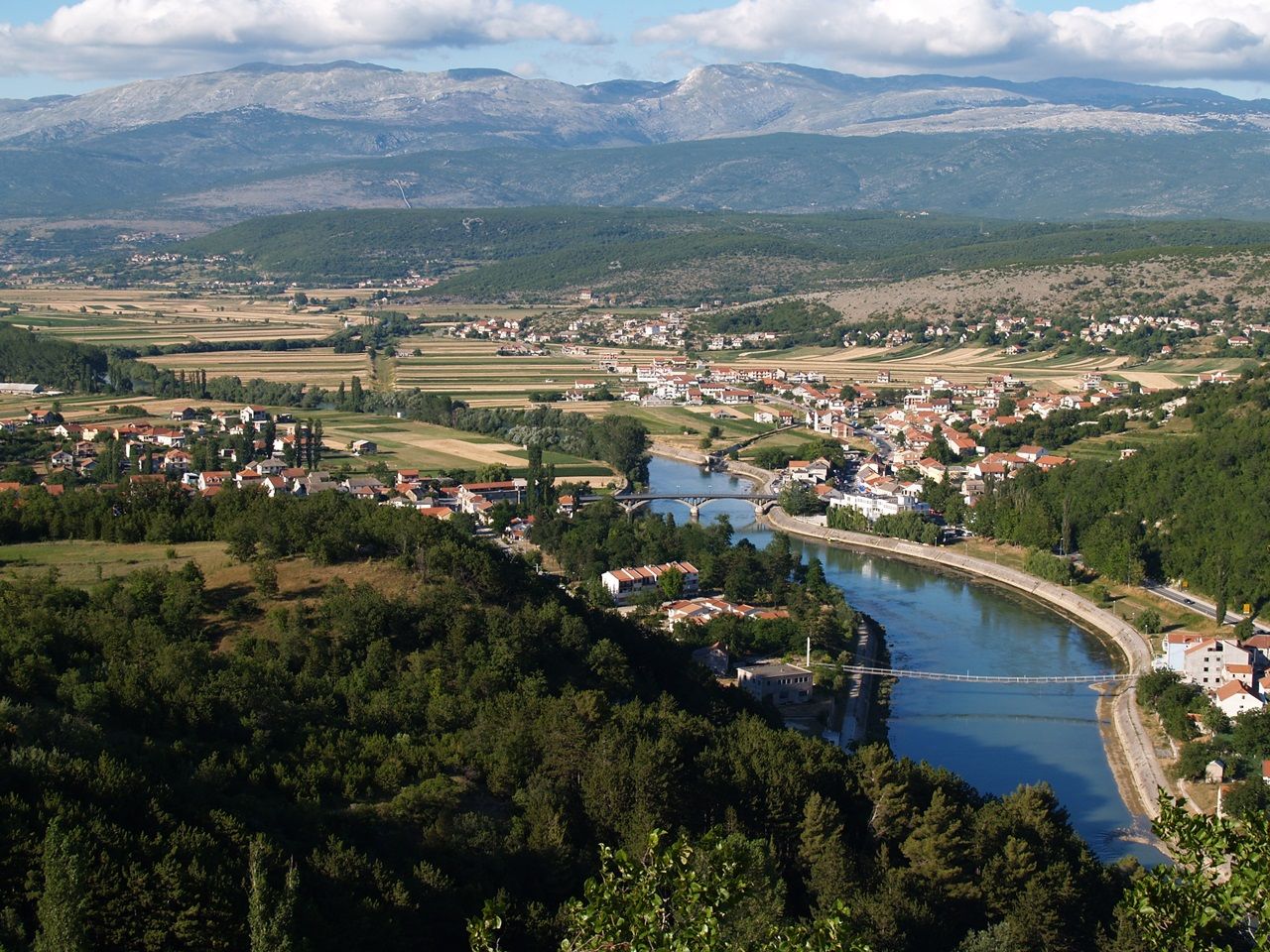 Trilj is a city in the Cetina region, located on the southeastern edge of Sinj Field. The position on the direction of the communication between the coast and inland, the natural features of the river Cetina and the nearby mountainous landscape, contributed to the continuity of life in Trilj region from the earliest prehistoric times.
In the area of Trilj there are many archaeological findings dating way back to Mesolithic. The first ethnic group that inhabited this area are the Illyrian tribe Delmati. Delmati people lived in a hill forts along the communication lines that connected their capital Delminium with Adriatic coast. Hundred and fifty years of fierce fighting against the Romans (165 BC.- 9. AD) ended in defeat of Delmati people, after which Romans built legionary fortress Tilurium on the hill above Trilj.
At the top of the hill of Gardun, just 1 km south of Trilj, remains of legionary fortress at Tilurium can be found. Tilurium guarded the entrance to the Cetina valley from the south and the approach to the provincial capital at Salona.
 Area: / m2 / / sq mi
Population 2011
- City: 2.110
- Urban: 10.799
Elevation: 315 m / 1.050 ft
Tourist Board:
- +385/21/ 832 510
- This email address is being protected from spambots. You need JavaScript enabled to view it.
City suburbs:
Bisko, Budimir, Čačvina, Čaporice, Gardun, Grab, Jabuka, Kamensko, Košute, Krivodol, Ljut, Nova Sela, Podi, Rože, Strizirep, Strmendolac, Tijarica, Ugljane, Vedrine, Velić, Vinine, Vojnić Sinjski, Voštane, Vrabač i Vrpolje
City of IMOTSKI
 Imotski is situated on the slopes of Podi hill just above the Imotski plane. The oldest traces of life in the wider surroundings of the town originate from prehistory with some findings from classical era. On the cliff overlooking the Blue Lake, the strong fortress Topana was built in early medieval age. In 10th century, it was the centre of one of eleven counties in the Croatian kingdom. In late 15th century, the fortress was conquered by Osman Empire. During their reign, Imotski has become important administrative centre, which is recorded in the verses of popular folk epic Asanaginica. After it was liberated from Ottoman Empire in 1717, the town has started to be formed over the time from scattered houses around the fortress. The town development was accelerated in late 19th and early 20th century. In mid-20th century Imotski has added industrial role to its administrative and trade roleS, and in recent times citizens started to hope for Imotski to become tourist centre thanks to its cultural heritage and natural beauties - Blue and Red Lake.
 Area: 73 km2
Population 2011
- City: 33.253
- Urban: 10.213
Elevation: 300 m / 1.000 ft
Tourist Board:
- +385/21/ 842 221 :: +385/98/ 433 341
- This email address is being protected from spambots. You need JavaScript enabled to view it.
City suburbs:
Donji Vinjani, Glavina Donja, Glavina Gornja, Gornji Vinjani, Imotski, Medvidovića Draga
City of Dugopolje
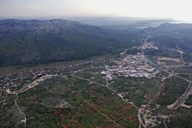 Dugopolje is a highly developed municipality in Croatia in the Split-Dalmatia County. It is a small town at the gates to Dalmatian inland, just 15 km from Split. Dugopolje has an ideal position, as it is located at the intersection of the state highway A1 Zagreb-Split-Dubrovnik and the highway D1 Split-Sinj, which connects the coast with the inland. Here in Dugopolje you can come to enjoy the natural beauty of the northern slopes of the Mosor Mountain and theVranjača cave, a protected geomorphologic natural monument in the village of Kotlenice. Or you can just come to shopping or watch football in Croatian Knights Sports Centre.
 Area: 64 km2
Population 2011
- Urban: 3.120
Elevation: ---
Tourist Board:
- +385/21/ --- ---
- ---
City suburbs:
Dugopolje, Koprivno, Kotlenice, Liska